★ 5919 pts. ♥ 0 likes ⬇ 9 saves
 Pict. [Wtf] Google Maps Satellite view of a dead body (#Wtf #Body #Dead #Google #Maps #Satellite)Pict. 1280×870 px
★ 2905 pts. ♥ 0 likes ⬇ 5 saves
 Pict. [Mapporn] The sub asks for interesting maps: this map I found online is interestingly wrong! [1050x1443] (#Map #Interesting #Wrong #Sub #Interestingly)Pict. 1050×1443 px
★ 6766 pts. ♥ 0 likes ⬇ 11 saves
 Pict. [Mapporn] My Secret Santa really knew how much I love maps (& Louisiana) [1836x3264] (#Love #Secret #Santa #Maps #Knew #Louisiana)Pict. 1836×3264 px
★ 5800 pts. ♥ 0 likes ⬇ 6 saves
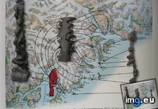
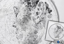
 Pict. [Mapporn] Carved, tactile maps of the Greenlandic coastlines [953x800] (#Maps #Carved #Coastlines #953x800 #Greenlandic #Tactile)Pict. 953×800 px
★ 6411 pts. ♥ 0 likes ⬇ 6 saves
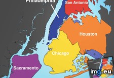
 Pict. [Mapporn] Big U.S. cities' populations squeezed into NYC. Spoiler alert: NYC is big. More maps in comments. [2652x2582] (#Big #Nyc #Maps #Squeezed #Spoiler)Pict. 2652×2582 px
★ 6712 pts. ♥ 0 likes ⬇ 9 saves
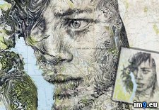
 Pict. [Pics] My mate does incredible portraits on maps 1 (#Incredible #Maps #Portraits #Mate)Pict. 755×1196 px
★ 9125 pts. ♥ 0 likes ⬇ 6 saves
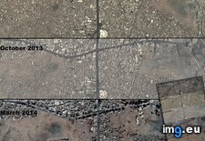
 Pict. [Mapporn] Satellite maps showing an enormous swath of historic Mecca cleared for construction [1689x2522] (more in comments) (#Showing #Maps #Cleared #Satellite #Enormous)Pict. 1689×2522 px
★ 6659 pts. ♥ 0 likes ⬇ 15 saves
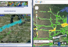
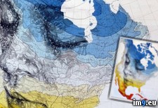
 Pict. [Mildlyinteresting] I was able to tell where it was snowing using the traffic feature on Google Maps (#Was #Google #Maps #Traffic #Feature #Snowing)Pict. 1318×616 px
★ -11072 pts. ♥ 0 likes ⬇ 9 saves
 Pict. [Pics] My mate does incredible portraits on maps 2 (#Incredible #Maps #Portraits #Mate)Pict. 500×782 px
★ 9252 pts. ♥ 0 likes ⬇ 9 saves
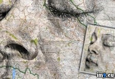
 Pict. [Pics] My mate does incredible portraits on maps 3 (#Incredible #Maps #Portraits #Mate)Pict. 700×762 px
★ 8896 pts. ♥ 0 likes ⬇ 2 saves
 Pict. [Pics] My mate does incredible portraits on maps 4 (#Incredible #Maps #Portraits #Mate)Pict. 700×700 px
★ 9050 pts. ♥ 0 likes ⬇ 3 saves
 Pict. [Mapporn] Inspired by the other maps that are split into regions with 1,000,000 people, I present to you North Dakota! (#People #Present #North #Regions #Split)Pict. 2865×1707 px
★ 6925 pts. ♥ 0 likes ⬇ 7 saves
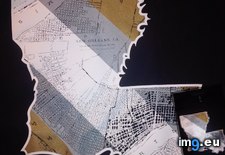
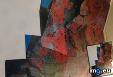
 Pict. [Pics] My mate does incredible portraits on maps 5 (#Incredible #Maps #Portraits #Mate)Pict. 700×967 px
★ 9043 pts. ♥ 0 likes ⬇ 4 saves
 Pict. [Mapporn] I used this infrared satellite photo of the Netherlands as a wall decoration. Do any more people here use maps as a fo (#Photo #People #Wall #Decoration #Infrared)Pict. 2448×3264 px
★ 7056 pts. ♥ 0 likes ⬇ 6 saves
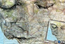
 Pict. [Pics] My mate does incredible portraits on maps 6 (#Incredible #Maps #Portraits #Mate)Pict. 700×725 px
★ 9060 pts. ♥ 0 likes ⬇ 3 saves
 Pict. [Pics] My mate does incredible portraits on maps 7 (#Incredible #Maps #Portraits #Mate)Pict. 700×913 px
★ 9244 pts. ♥ 0 likes ⬇ 7 saves
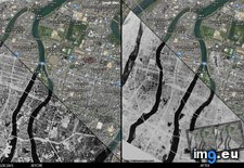
 Pict. [Mapporn] Hiroshima atomic bomb. BEFORE and AFTER + google maps. [1600x830] (#Google #Maps #Bomb #Atomic #Hiroshima)Pict. 1600×830 px
★ 5405 pts. ♥ 0 likes ⬇ 16 saves
 Pict. [Mapporn] We've all seen maps of landlocked countries...here's a map of landlocked first level administrative divisions [4972x25 (#Map #Countries #Divisions #Administrative #Landlocked)Pict. 4972×2517 px
★ 7240 pts. ♥ 0 likes ⬇ 10 saves
 Pict. [Mildlyinteresting] This Google maps marker was in the middle of a circle of people. (#Was #People #Google #Maps #Circle #Marker)Pict. 1736×857 px
★ -11104 pts. ♥ 0 likes ⬇ 18 saves
 Pict. maps-and-keys-chart (#Maps #Chart #Keys)Pict. 603×735 px
★ 1889 pts. ♥ 0 likes ⬇ 9 saves
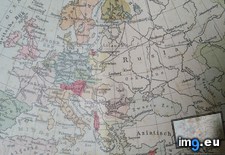
 Pict. [Mapporn] Border Uncertainties: 1920 Map Published During Polish-Soviet War and Before Signing of Trianon Treaty (More maps in c (#Map #Polish #Soviet #Published #Signing)Pict. 3984×2241 px
★ 6142 pts. ♥ 0 likes ⬇ 8 saves
 Pict. [Mapporn] Stylized empire maps from the game Civilization V (full album in comments)[347x403] (#Album #Game #Empire #Civilization #Stylized)Pict. 347×403 px
★ 6430 pts. ♥ 0 likes ⬇ 7 saves
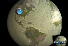
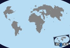
 Pict. mapporn-all-the-water-on-earth-presented-as-a-sphere-it-would-have-a-diameter-of-about-860-miles-and-a-volume-around-332-500-000-cubic-miles-1600-1534 (#White #World #Map #Best #Europe #Water #Miles #Geography #Statistics #Presented #Diameter #Sphere #Cubic)Pict. 950×911 px
★ 10k pts. ♥ 0 likes ⬇ 5 saves